NextCore RN50 Drone LiDAR
 Cendence-S Remote Controller For M200 V2 Series
 DJI FPV Lumicopter
 SlantRange 4P+
 DJI Dock 2
 DJI FlyCart 30
 AGRAS T50
 AGRAS T25
 DJI Mavic 3 Multispectral With 1 Year Care Basic
  DJI Mavic 3 Enterprise With 1 Year Care Basic
 DJI Mavic 3 ThermalWith 1 Year Care Basic
 DJI Mavic 3 Enterprise with 2 Year Care Basic
 Matrice M30
 Matrice M30T
 Matrice M30 with Enterprise Care Plus
 Matrice M30T with Enterprise Care Plus
 Deepthink S2 Pro Night Vision Payload for Matrice 300 Series
 Matrice 350 RTK
 DJI RC Plus for Matrice Series
 Zenmuse H20N
 DJI RC Plus for DJI FlyCart 30
 DJI Matrice 3D
 DJI Matrice 3TD
 DJI Dock
  DJI Power 1000
 Tello
Tello Tello Boost Combo
 Tello EDU
 RoboMaster S1
 GameSir T1d Controller
 SunnyLife Carrying Case for Tello
 Tello Flight Battery
 SunnyLife Battery Charging Hub for Tello
 Sunnylife Carrying Bag For DJI RoboMaster S1
  RoboMaster S1 PlayMore Kit V2
  RoboMaster S1 Intelligent Battery V2
  RoboMaster S1 Gamepad V2
 SanDisk Extreme Pro 128GB 200MB/s MicroSD Card
 SanDisk Extreme Pro 256GB 200MB/s MicroSD Card
 SanDisk Extreme Pro 512GB 200MB/s MicroSD Card
 PGYTECH CreateMate High-Speed Card Reader Case
 DJI Mini 4 Pro Fly More Combo
 DJI Mini 4 Pro Fly More Combo Plus
 DJI Mini 4 Pro
 DJI Mini 4 Pro w. DJI RC 2
 DJI Mini 3 Pro with DJI RC
  DJI RC
 DJI Mini 3
 DJI Mini 3 w. DJI RC
 DJI Mini 3 Fly More Combo Plus
 DJI Mini 3 Fly More Combo Plus w. DJI RC
 DJI Mini 2 SE
 DJI Mini 2 SE Fly More Combo
 DJI Mini SE
  DJI Mini 2
 DJI Mini 2 Fly More Combo
  Ex-Demo Mavic Mini Fly More Combo
 Mavic Mini
 Mavic Mini Fly More Combo
  DJI Air 3 Fly More Combo w. DJI RC 2
 DJI Air 3
 DJI Air 3 Fly More Combo
 DJI Air 2S
 DJI Air 2S Fly More Combo
 Mavic Air 2 Fly More Combo
 Mavic Air 2
 Ex-Demo Mavic Air Combo (Onyx Black)
 Ex-Demo Mavic Air Combo (Flame Red)
 Ex-Demo Mavic Air Combo (Arctic White)
 Ex-Demo Mavic Air (Arctic White)
 DJI Mavic 3 Pro w. DJI RC
 DJI Mavic 3 Pro Fly More Combo w. DJI RC
 DJI Mavic 3 Pro Fly More Combo w. DJI RC Pro
 DJI Mavic 3 Pro Cine Premium Combo
 DJI Mavic 3 Classic w. DJI RC
  DJI Mavic 3 Classic w. DJI RC-N1
 DJI Mavic 3 Classic (Drone Only)
 Ex-Demo Mavic 3 Classic w. DJI RC
 DJI Mavic 3
  DJI Mavic 3 Fly More Combo
  DJI Mavic 3 Cine Combo w. DJI RC-N1
 DJI RC Pro Controller
 Ex-Demo Mavic 2 Pro Fly More Combo
 Mavic 2 Zoom
 Mavic 2 Pro
 Ex-Demo Mavic Pro
 Mavic Pro Fly More Combo
 Demo Mavic Pro Platinum Combo
 DJI Avata 2 Fly More Combo
 DJI Avata 2 Fly More Combo (Three Batteries)
 DJI Avata Explorer Combo
 DJI Avata
  DJI Avata Pro-View Combo w. DJI RC Motion 2
 DJI Avata Fly Smart Combo
 DJI Goggles 3
 DJI Goggles Integra Motion Combo
 DJI Goggles Integra
 DJI Goggles 2 Motion Combo
 DJI FPV Combo
  DJI O3 Air Unit
 Osmo Pocket 3 Standard Combo
 Osmo Pocket 3 Creator Combo [Back-Order]
 Osmo Action 4 Standard Combo
 Osmo Action 4 Adventure Combo
 DJI Mic 2 Dual Microphone Combo
 DJI Mic 2 Single Microphone Kit
 Osmo Mobile 6 (Slate Grey)
 Osmo Mobile 6 (Platinum Grey)
 Osmo Mobile SE
 Osmo Action 3 Standard Combo
 Osmo Action 3 Adventure Combo
  DJI Mic Single Microphone Kit
 DJI Mic Dual Microphone Combo
 DJI Pocket 2
 DJI Pocket 2 Creator Combo
 DJI Pocket 2 Exclusive Combo | Sunset White
 DJI Action 2 Dual-Screen Combo (128GB)
 DJI Action 2 Power Combo (128GB)
 DJI Action 2 Dual Screen Combo
 DJI Action 2 Power Combo
 DJI Osmo Action
  Osmo Pocket
 DJI RS 4
 DJI RS 4 Combo
 DJI RS 4 Pro
 DJI RS 4 Pro Combo
 DJI RS 3
 DJI RS 3 Combo
 DJI RS 3 Pro
 DJI RS 3 Pro Combo
 DJI RS 2
 DJI RS 2 Pro Combo
 DJI RSC 2
 DJI RSC 2 Pro Combo
 Ronin-S
 Ronin-SC
 Ronin 2 Professional Combo
  Ronin 4D-6K
 Ronin 4D-8K
 Zenmuse X9-8K Gimbal Camera
 DJI Ronin 4D Flex
 DJI Inspire 3
 DJI Focus Pro Creator Combo
 DJI Focus Pro All-In-One Combo
 DJI Transmission (High-Bright Monitor Combo)
 DJI Transmission (Standard Combo)
 DJI Video Transmitter
 DJI Video Receiver
 DJI DL 24mm F2.8 LS ASPH Lens
 DJI DL-S 16mm F2.8 ND ASPH Lens
 DJI DL 35mm F2.8 LS ASPH Lens
 DJI DL 50mm F2.8 LS ASPH Lens
 Inspire 2
  Inspire 2 Includes Apple ProPres & CinemaDNG Licenses
 Ex-Demo Inspire 2
 XCD 3,5/45
 XCD 2,5/38V
 XCD 45P
 XCD 2,5/55V
 D1 Labs Landing Pad Pro (50CM)
 UGREEN 100W USB-C Charging Station
 Caution Drone Safety Sign
 D1 Labs Air Duster Pro
 DJI Care Refresh 1-Year Plan (DJI Mini 3 Pro)
 DJI Care Refresh 2-Year Plan (DJI Mini 3 Pro)
 DJI Mini 3 Series Intelligent Flight Battery
 DJI Mini 4 Pro/Mini 3 Series Intelligent Flight Battery Plus
 DJI Care Refresh 1-Year Plan (DJI Mavic 3)
 DJI Care Refresh 2-Year Plan (DJI Mavic 3)
 DJI Care Refresh 1-Year Plan (DJI Mavic 3 Cine)
 DJI Care Refresh 2-Year Plan (DJI Mavic 3 Cine)
 Mavic 2 Intelligent Flight Battery
 Mavic 2 Low-Noise Propellers (Pair) [No Retail Packaging}
 Mavic 2 Protector Case
 DJI Smart Controller
  Gimbal Camera Cover for DJI Phantom 4 Pro
 Phantom 4 Series Intelligent Flight Battery
 Phantom 4 Car Charger
 Phantom 4 Battery Charging Hub
 SunnyLife Propellers for Mavic Mini
 Mavic Mini Intelligent Flight Battery
 DJI Mini 2 / SE Two-Way Charging Hub
 Mavic Mini Propellers (set)
 PGYTECH CPL Filter for Osmo Pocket Series (Professional)
 DJI Pocket 2 Phone Clip
 Osmo Pocket 3.5mm Adapter
 Osmo Pocket Extension Rod
 Osmo Action Battery
 Osmo Action Charging Kit
 CYNOVA Osmo Action Dual 3.5mm/USB-C Adapter
 SunnyLife Carrying Case for Osmo Mobile SE / OM4 Series
 DJI Osmo Mobile Magnetic Phone Clamp
 DJI Osmo Mobile Magnetic Ring Holder
 DJI OM Magnetic Phone Clamp 3
 Mavic Air Intelligent Flight Battery
  Mavic Air Remote Controller(Open Box)
 Mavic Air Carrying Case
 Mavic Air Battery Charging Hub
 Lens Filter for Mavic Pro (G-HD-ND8)
 Mavic Pro Intelligent Flight Battery
 Gannet Sport for DJI Mavic Series
 Ex-Demo Mavic Pro Remote Controller
 SunnyLife Propellers for DJI Spark
 Spark - Propeller Guards
 Spark - Quick-Release Folding Propellers
 SunnyLife Spark Intelligent Battery Car Charger With USB Port
 Ex-Demo Zenmuse X5S
 DJI Care Refresh (Inspire 2)
 Zenmuse X5S
 Zenmuse X7 (Lens Excluded)
 EM-D1 Drone Skin for DJI Mini 3 Pro
 EM-D1 Drone Skin for DJI Mavic 3 Series
 D1 Labs EM-D1 Desk Pad (Ultraviolet)
 D1 Labs EM-D1 Desk Pad (Stellar)
 PolarPro Vivid Collection Filters for Mavic Air 2 (3 Pack)
 PolarPro 2 to 5 Stop VND Filter for Mavic Air 2
 PolarPro CrystalSky Mount | Mavic/Spark
  PolarPro Mavic 2 Pro Cinema Series 2-5 Stop VND Filter
 UGREEN 65W USB-C Charging Station
 UGREEN HiTune T3 Active Noise Cancelling Earbuds (Black)
 UGREEN HiTune T3 Active Noise Cancelling Earbuds (White)
 Gannet Sport for Phantom Series
 Gannet Electronic Payload Release System for Mavic 2
 Gannet Elite for DJI Mavic 3 Series
 DJI Matrice 300 6 Battery Case
 GPC Hard Case for DJI M30 Series
 GPC Safety Case for DJI Air 2S
 GPC Safety Case for DJI FPV
 D1 VIP Drone Set-Up Service
 D1 Beginners Flight Training (Brunswick, VIC)
 Remote Pilots License (RePL)
  DJI Maintenance Course Training
 D1 Labs Landing Pad Pro (65CM)
 D1 Labs Landing Pad Pro (100CM)
 D1 Labs Weighted Drone Landing Pad (67CM)
 Ulanzi RGB Handheld Tube Light | VL119
 Ulanzi Vijim RGB Light | VL120
 Ulanzi Mini RGB LED Light | VL49
  Ulanzi Waterproof Cube Light
 PGYTECH OneMo Lite Backpack 22L
 PGYTECH OneMo FPV Backpack
 PGYTECH OneGo Backpack 18L | Obsidian Black
 PGYTECH OneMo 2 Backpack 25L | Space Black
 SunnyLife Bicycle Mount for DJI RC-N1/N2
 Mavic Tablet Holder v2
 PGYTECH Tablet Holder V2
 DJI RC-N1/N2 Control Sticks
 DJI Drone Controller Lanyard
 SunnyLife Control Sticks for DJI RC Series
 SunnyLife Rocker Speed Controller for DJI RC
 Bicycle Bracket & Clamp for DJI RC Pro
 SunnyLife Sun Hood for DJI RC Pro
 SunnyLife 2 in 1 Controller Protector for DJI RC Pro
 BRDRC Hard-Shell Drone Strobe Light
 Retractable Drone Safety Cone 450mm
 PGYTECH Mantispod
 PGYTECH Mantispod Pro
 Freewell Split ND Filters for DJI Air 3 (4 Pack)
 Freewell All Day Filters for Osmo Pocket 3 (8 Pack)
 Freewell Bright Day Filters for Osmo Pocket 3 (4 Pack)
 Freewell CPL Filter for Osmo Pocket 3
 Freewell Sherpa Series Case for iPhone 13 Pro Max
 Freewell Sherpa Series Case for iPhone 14 Pro Max
 Freewell Sherpa Series Case for iPhone 15 Pro
 Freewell Galaxy Series Case for Samsung Galaxy S23 Ultra
 Freewell Galaxy Series Case for Samsung Galaxy S24 Ultra
 Freewell Galaxy Series ND Filters (4 Pack)
 Freewell Galaxy Series Snow Mist 1/4 Filter
 DJI FPV Remote Controller 3
 DJI RC Motion 3
 DJI RC 2
 PGYTECH CFexpress CreateMate Card Reader Case (CFE-B/SD)
 PGYTECH Camera Shoulder Strap
 PGYTECH Camera Wrist Strap
 D1 Labs Lanyard Bracket for DJI RC Series
 SunnyLife Sun Hood for DJI RC 2
 SunnyLife 2 in 1 Controller Protector for DJI RC 2
 UGREEN USB-C to USB-C Cable (1 Metre)
 DJI Care Refresh 1-Year Plan (DJI Mavic 3 Pro)
 DJI Care Refresh 1-Year Plan (DJI Mini 4 Pro)
 DJI Care Refresh 1-Year Plan (DJI Mavic 3 Pro Cine)
 DJI Care Refresh 1-Year Plan (DJI Air 3)
 DJI Care Refresh 1-Year Plan (Osmo Action 4)
 DJI Care Refresh 2-Year Plan (DJI Mavic 3 Pro Cine)
 DJI Care Refresh 2-Year Plan (DJI Air 3)
 DJI Care Refresh 2-Year Plan (Osmo Action 4)
 DJI Care Refresh 2-Year Plan (DJI Mini 4 Pro)
 Enterprise Shield For Mavic 2 Zoom
 Enterprise Shield For Phantom 4 RTK
 Enterprise Shield Mavic 2 Dual
 Enterprise Shield Basic Renew (M200 V2)
 Enterprise Shield Basic Renew (M210 RTK V2)
 Enterprise Shield Basic Renew (M210 V2)
 Enterprise Shield Basic Renew (Mavic 2 Enterprise Dual)
 PGYTECH U-Bolt Mount
 PGYTECH CapLock Action Camera Extension Pole Tripod
 PGYTECH Super Clamp Mount
 D1 Labs Safety Case Foam Insert for DJI Mini 4 Pro
 D1 Labs Safety Case for DJI Mini 3 Pro
 D1 Labs Safety Case for DJI Mini 4 Pro
 D1 Labs Safety Case for DJI Air 3
 Spectre | Drone Brick Model
  D1 Labs Tidal Wave Desk Pad
 D1 Labs Screen & Lens Protector for Osmo Action 4
 D1 Labs Screen & Lens Protector for Osmo Pocket 3
 D1 Labs Screen Protector for DJI RC Plus
 D1 Labs Screen Protector for DJI RC Pro
 Yule Whispers Drone Skin for DJI Mini 4 Pro
 Auspicious Sky Drone Skin for DJI Mini 4 Pro
 Auspicious Sky Drone Skin for DJI Air 3
 Auspicious Sky Drone Skin for DJI Mavic 3 Series
 Auspicious Sky Drone Skin for DJI Mini 3 Pro
 Yule Whispers Drone Skin for DJI Mini 3 Pro
 Cerulean Flight Drone Skin for DJI Mini 3 Pro
 PGYTECH DJI RC Protector
 DJI Action 2 Waterproof Case
 PGYTECH ND/PL Filters for DJI Mavic 3 (4 Pack)
 SunnyLife Full Gimbal Cover for DJI Mavic 3
 Ex-Demo DJI Mavic 3
 Ex-Demo DJI Avata Fly Smart Combo
 Ex-Demo DJI Avata Fly More Kit
 Ex-Demo DJI RS 3
 Ex-Demo DJI RS 3 Combo
 Ex-Demo DJI RS2
 Ex-Demo DJI OM 5 (Athens Grey)
 Ex-Demo Tello Battery
 Ex-Demo DJI Mini 2 / SE Intelligent Flight Battery
 Ex-Demo DJI Mini 3 Series Intelligent Flight Battery
 Ex-Demo DJI Mini 3 Series Intelligent Flight Battery Plus


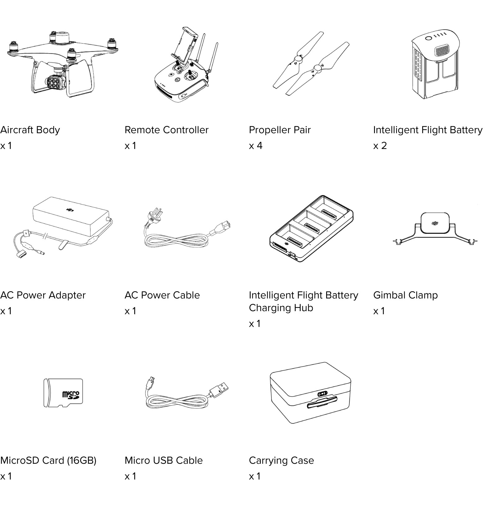
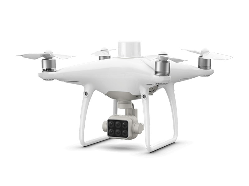
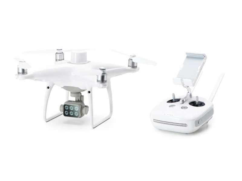
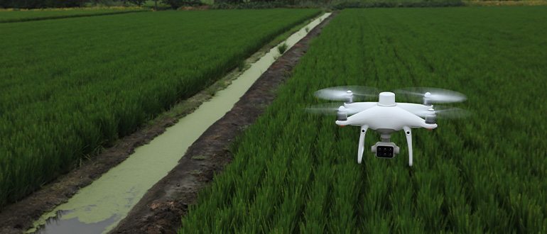
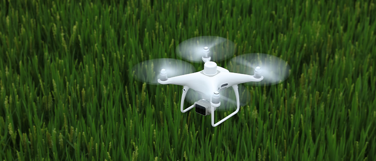
Gather precise plant-level data using the P4 Multispectral – a high-precision drone with a seamlessly integrated multispectral imaging system built for agriculture missions, environmental monitoring, and more.


Gather precise plant-level data using the P4 Multispectral – a high-precision drone with a seamlessly integrated multispectral imaging system built for agriculture missions, environmental monitoring, and more.
AUD $9,299.00
Gather precise plant-level data using the P4 Multispectral – a high-precision drone with a seamlessly integrated multispectral imaging system built for agriculture missions, environmental monitoring, and more.
▪ Multispectral Imaging System
▪ Live NDVI View
▪ RTK Module
▪ TimeSync
The P4 Multispectral consolidates the process of capturing data that gives insight into crop health and vegetation management. DJI has created this platform with the same powerful performance standards that DJI is known for, including 27 minutes max flight time and up to 7 km1 transmission range with the OcuSync system.
See Beneath the Surface
Agriculture imagery collection is now simpler and more efficient than ever before with a built-in stabilized imaging system that collects comprehensive data sets right out of the box. Access information collected by 1 RGB camera and a multispectral camera array with 5 cameras covering Blue, Green, Red, Red Edge, and Near Infrared bands – all at 2 MP with global shutter, on a 3-axis stabilized gimbal.
An integrated spectral sunlight sensor on top of the drone captures solar irradiance, which maximizes accuracy and consistency of data collection through different times of day. When combined with post-processed data, this information helps to obtain the most accurate NDVI results.
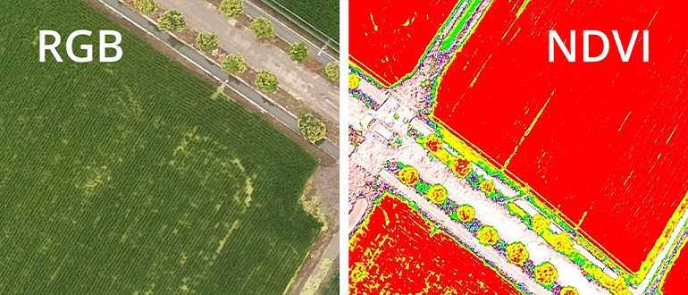
Simply having aerial imagery is not enough for ag professionals who want to know more. Switch between a preliminary Normalized Difference Vegetation Index (NDVI) analysis and the live RGB feed to immediately visualize where attention is needed, so targeted treatment decisions can be made quickly.
Get real-time, accurate positioning data on images captured by all six cameras with DJI’s TimeSync system, providing centimeter-level accurate measurements. The TimeSync system continually aligns the flight controller, RGB and NB cameras, and RTK module, fixing the positioning data to the center of the CMOS and ensuring each photo uses the most accurate metadata. All cameras go through a rigorous calibration process where radial and tangential lens distortions are measured. The distortion parameters gathered are saved into each image’s metadata, letting post-processing software adjust uniquely for every user.
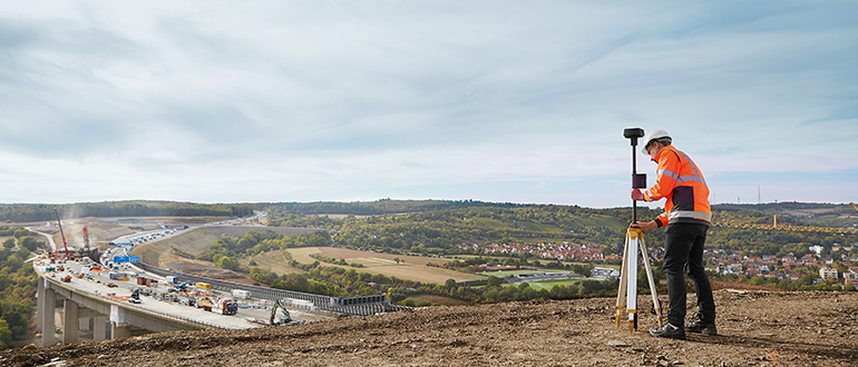
Enhance the accuracy of RTK positioning without internet connection by connecting the P4 Multispectral to the D-RTK 2 High Precision GNSS Mobile Station and NTRIP (Network Transport of RTCM via Internet Protocol)2, or store the satellite observation data to be used for Post Processed Kinematics (PPK).
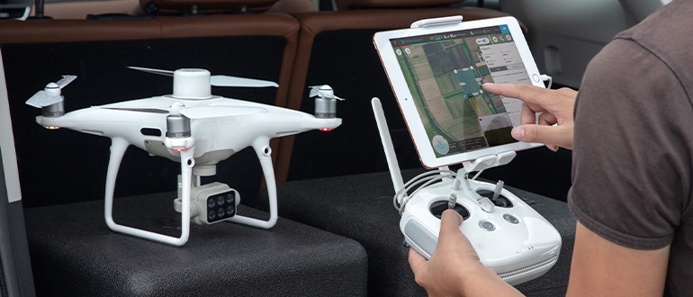
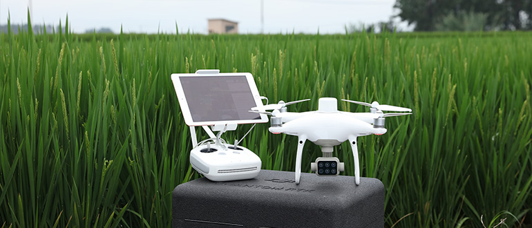
Plan Flights
Plan flights, execute automated missions, and manage flight data using GS PRO – DJI’s leading flight planning iOS app.
Capture Data
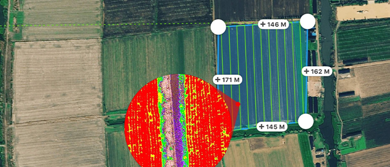
Collect multispectral images efficiently across a large area using the P4 Multispectral and gain an overview of problem areas.
Analyze Data
Easily access and process aerial data by applying plant-specific metrics and parameters to acquire the desired results on plant health.
Our Enterprise team are dedicated to providing you with the best service and price on all your DJI enterprise needs from RPAS to Payloads to Software. With our conveniently located enterprise hubs around Australia, our product specialists will be with you and your company every step of the way from finding the right drone to maintence. Enjoy exclusive services with D1 Enterprise such as Rentals, Repairs, Training and Maintenance.