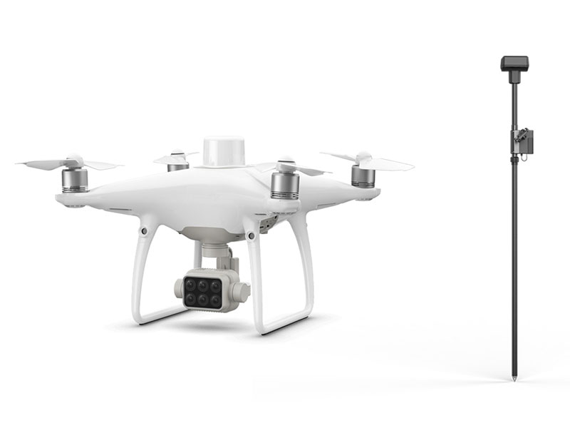
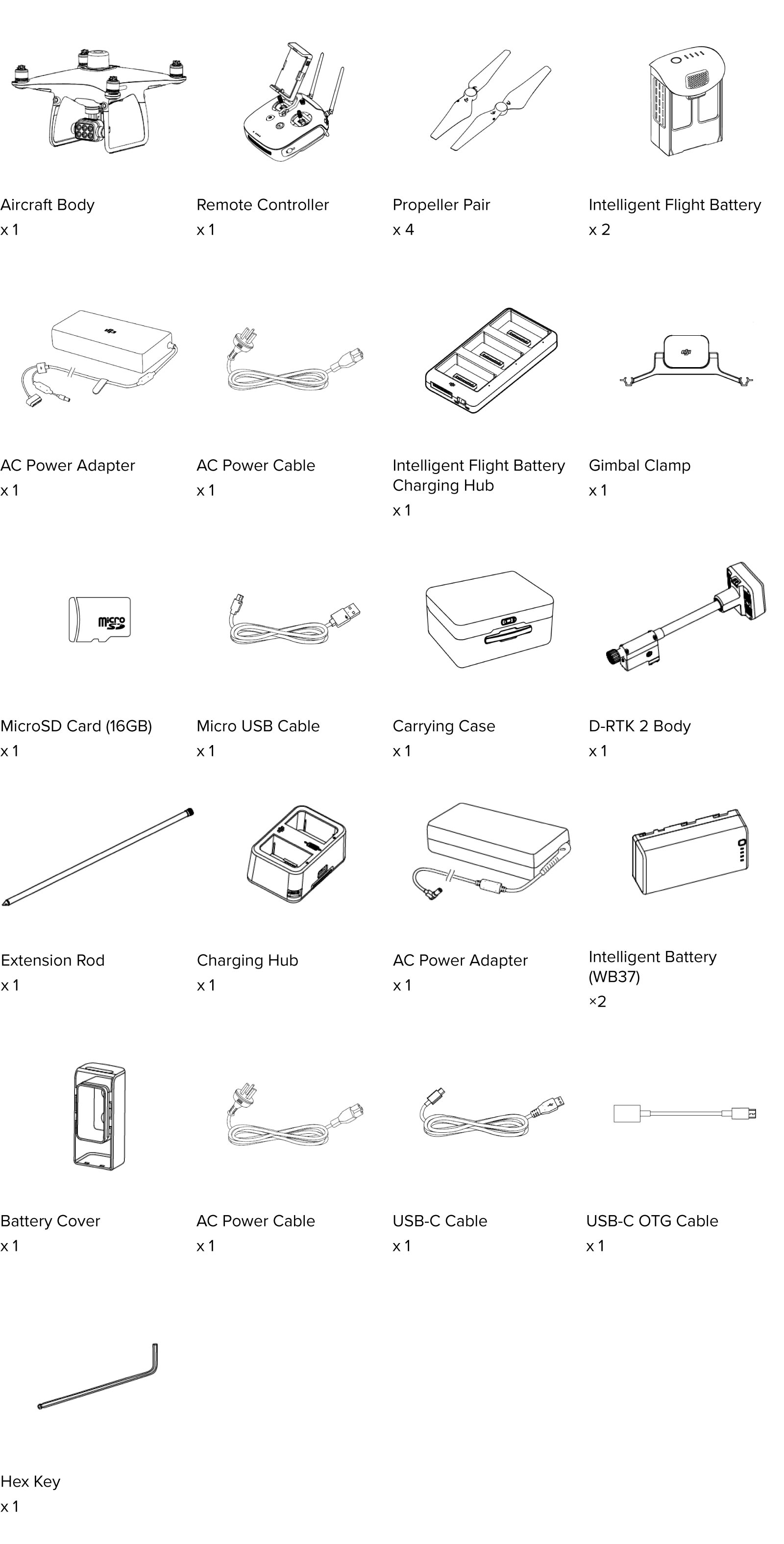
Phantom 4 Multispectral + D-RTK 2 High Precision GNSS Mobile Station Combo
Item Code: BM-P4MSC
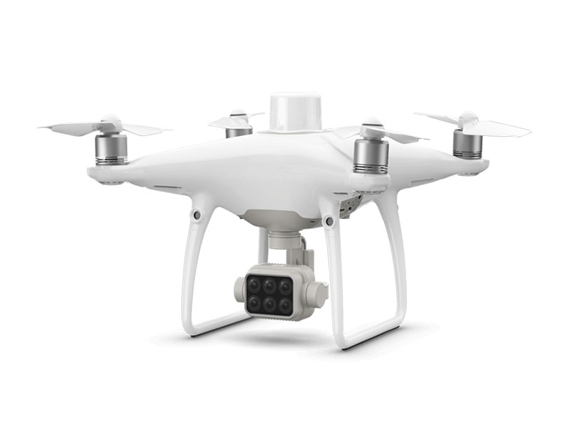
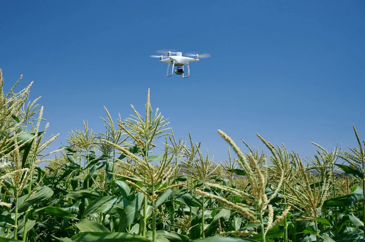
Gather precise plant-level data using the P4 Multispectral – a high-precision drone with a seamlessly integrated multispectral imaging system built for agriculture missions, environmental monitoring, and more.
The P4 Multispectral consolidates the process of capturing data that gives insight into crop health and vegetation management. DJI has created this platform with the same powerful performance standards that DJI is known for, including 27 minutes max flight time and up to 7 km1 transmission range with the OcuSync system.
See Beneath the Surface
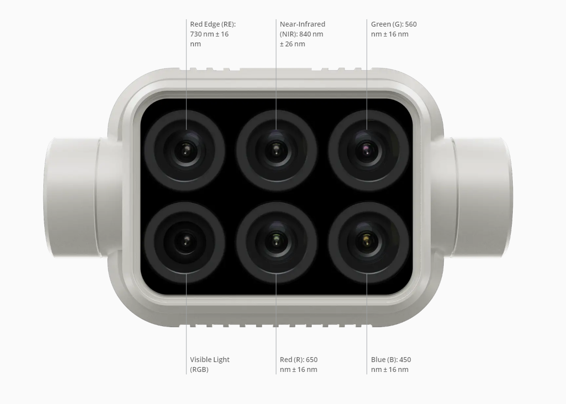
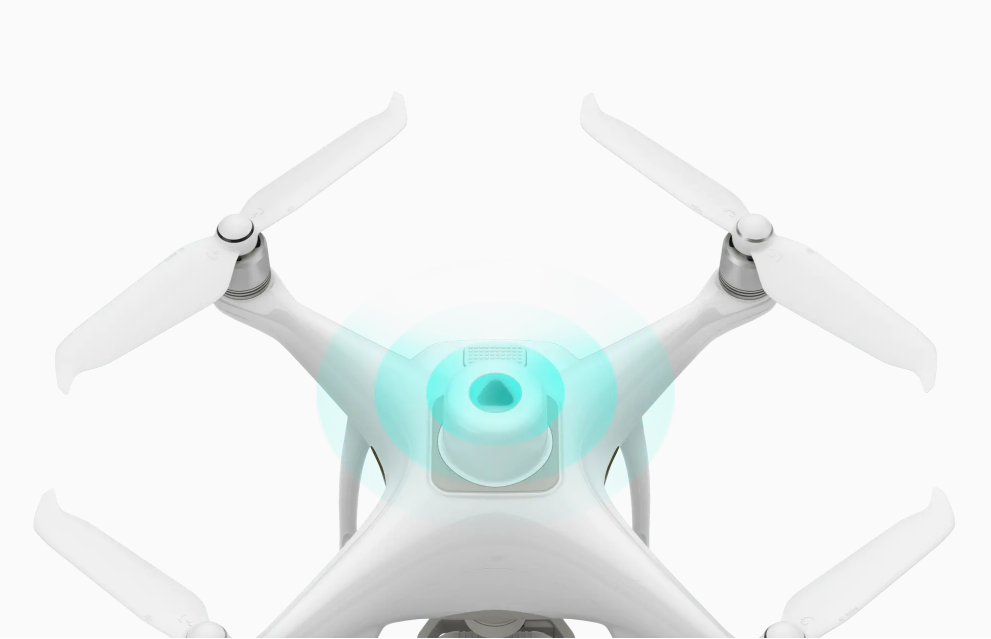
Agriculture imagery collection is now simpler and more efficient than ever before with a built-in stabilized imaging system that collects comprehensive data sets right out of the box. Access information collected by 1 RGB camera and a multispectral camera array with 5 cameras covering Blue, Green, Red, Red Edge, and Near Infrared bands – all at 2 MP with global shutter, on a 3-axis stabilized gimbal.
Integrated Spectral Sunlight Sensor for Accurate Results
An integrated spectral sunlight sensor on top of the drone captures solar irradiance, which maximizes accuracy and consistency of data collection through different times of day. When combined with post-processed data, this information helps to obtain the most accurate NDVI results.
Meaningful Data at Your Disposal
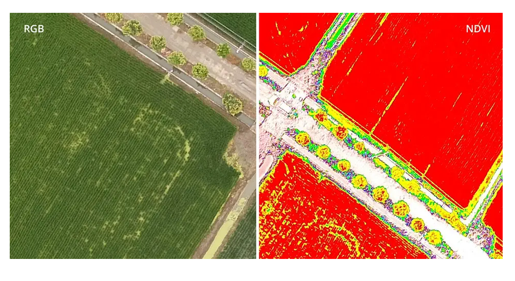
View Both RGB and NDVI Feeds
Simply having aerial imagery is not enough for ag professionals who want to know more. Switch between a preliminary Normalized Difference Vegetation Index (NDVI) analysis and the live RGB feed to immediately visualize where attention is needed, so targeted treatment decisions can be made quickly.
Centimeter-level Precision
Get real-time, accurate positioning data on images captured by all six cameras with DJI’s TimeSync system, providing centimeter-level accurate measurements. The TimeSync system continually aligns the flight controller, RGB and NB cameras, and RTK module, fixing the positioning data to the center of the CMOS and ensuring each photo uses the most accurate metadata. All cameras go through a rigorous calibration process where radial and tangential lens distortions are measured. The distortion parameters gathered are saved into each image’s metadata, letting post-processing software adjust uniquely for every user.
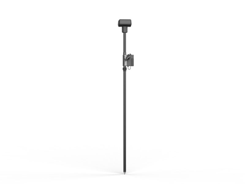
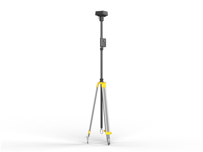
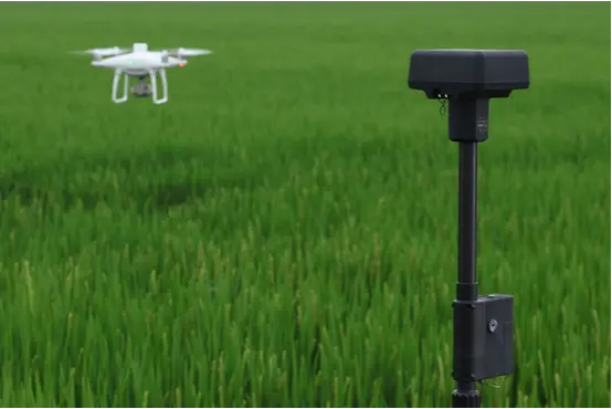
D-RTK 2 Mobile Station and NTRIP Compatibility
Enhance the accuracy of RTK positioning without internet connection by connecting the P4 Multispectral to the D-RTK 2 High Precision GNSS Mobile Station and NTRIP (Network Transport of RTCM via Internet Protocol)2, or store the satellite observation data to be used for Post Processed Kinematics (PPK).
The Beginning of Intelligent Agriculture Missions
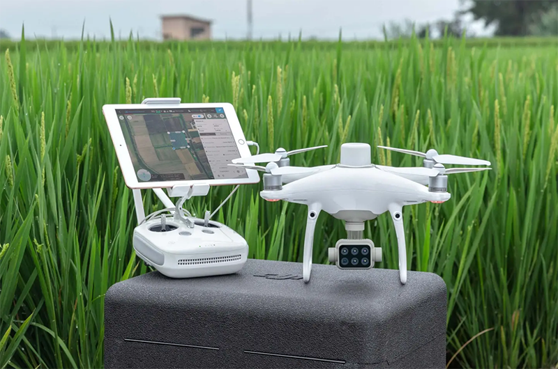
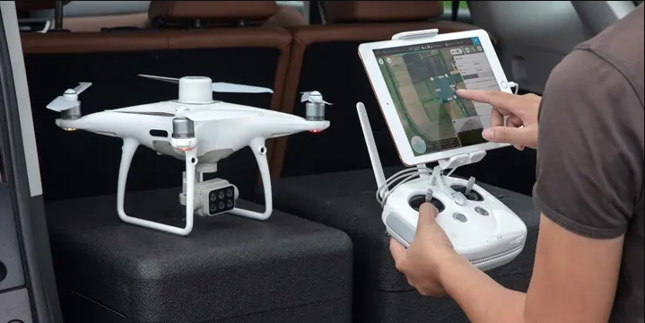
Plan Flights
Plan flights, execute automated missions, and manage flight data using GS PRO – DJI’s leading flight planning iOS app.
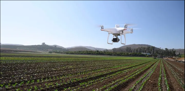
Capture Data
Collect multispectral images efficiently across a large area using the P4 Multispectral and gain an overview of problem areas.
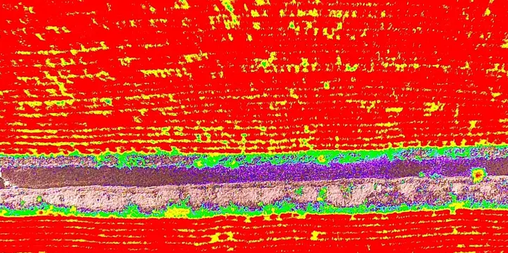
Analyze Data
Easily access and process aerial data by applying plant-specific metrics and parameters to acquire the desired results on plant health.
Applications
Precision agriculture
Throughout all growing seasons, multispectral imagery can be helpful to ag professionals by providing information invisible to the human eye across the electromagnetic spectrum. Having access to this data and the subsequently obtained Vegetation Index data such as NDRE and NDVI, farmers can make timely, informed decisions on crop treatment, lowering costs, saving resources, and maximizing yields.
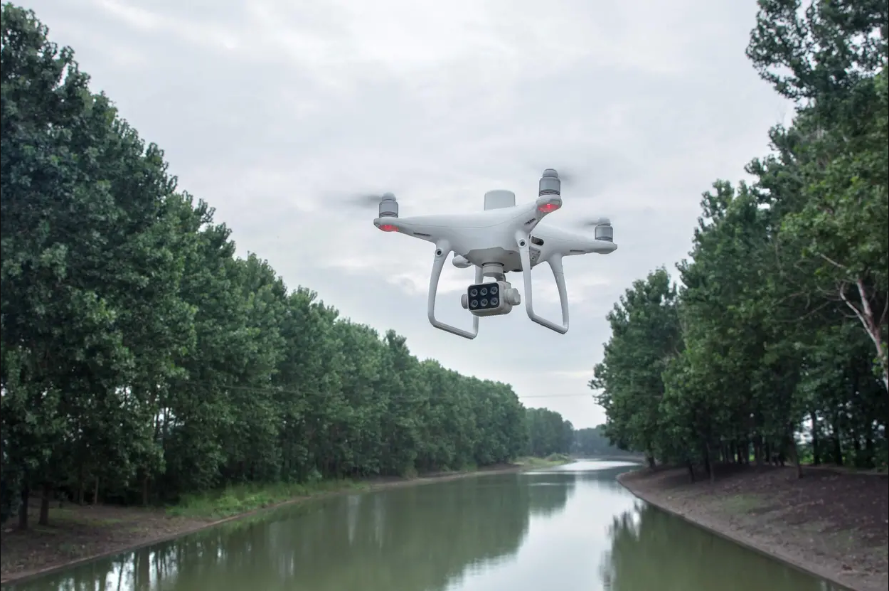
Environmental monitoring and inspection
Routine inspections and maintenance involving plants can be made smarter and more efficient when using the P4 Multispectral – leverage its actionable multispectral insights to monitor forest health, measure biomass, map shorelines, or manage riparian vegetation while protecting habitats or ecosystems, and much more.
RTK enabled and functioning properly: Vertical: ± 0.1 m; Horizontal: ± 0.1 m RTK disabled: Vertical: ± 0.1 m (with vision positioning); ± 0.5 m (with GNSS positioning) Horizontal: ± 0.3 m (with vision positioning); ± 1.5 m (with GNSS positioning)
Image Position Compensation
The relative positions of the centers of the six cameras’ CMOS and the phase center of the onboard D-RTK antenna have been calibrated and are recorded in the EXIF data of each image.
Frequency Used GPS: L1/L2; GLONASS: L1/L2; BeiDou: B1/B2; Galileo[2]: E1/E5 First-Fixed Time: < 50 s Positioning Accuracy: Vertical 1.5 cm + 1 ppm (RMS); Horizontal 1 cm + 1 ppm (RMS). 1 ppm indicates error with a 1 mm increase over 1 km of movement. Velocity Accuracy: 0.03 m/s
Mapping Functions
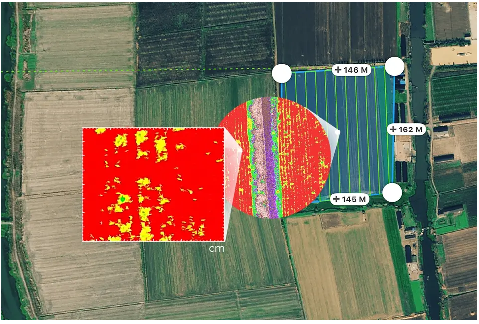
Ground Sample Distance (GSD)
(H/18.9) cm/pixel, H indicates the aircraft altitude relative to the area mapped (unit: m)
Rate of Data Collection
Max operating area of approx. 0.47 km2 for a single flight at an altitude of 180 m, i.e., GSD is approx. 9.52 cm/pixel
Gimbal
Controllable Range
Tilt: -90° to +30°
Vision System
Velocity Range
≤ 31 mph (50 kph) at 6.6 ft (2 m) above ground with adequate lighting
Altitude Range
0 - 33 ft (0 - 10 m)
Operating Range
0 - 33 ft (0 - 10 m)
Obstacle Sensory Range
2 - 98 ft (0.7 - 30 m)
Operating Environment
Surfaces with clear patterns and adequate lighting (> 15 lux)
Camera
Sensors
Six 1/2.9” CMOS, including one RGB sensor for visible light imaging and five monochrome sensors for multispectral imaging. Each Sensor: Effective pixels 2.08 MP (2.12 MP in total)
Filters
Blue (B): 450 nm ± 16 nm; Green (G): 560 nm ± 16 nm; Red (R): 650 nm ± 16 nm; Red edge (RE): 730 nm ± 16 nm; Near-infrared (NIR): 840 nm ± 26 nm
Lenses
FOV (Field of View): 62.7° Focal Length: 5.74 mm (35 mm format equivalent: 40 mm), autofocus set at ∞ Aperture: f/2.2
RGB Sensor ISO Range
200 - 800
Monochrome Sensor Gain
1 - 8x
Electronic Global Shutter
1/100 - 1/20000 s (visible light imaging); 1/100 - 1/10000 s (multispectral imaging)

 NextCore RN50 Drone LiDAR
 Cendence-S Remote Controller For M200 V2 Series
 DJI FPV Lumicopter
 SlantRange 4P+
 DJI Mavic 3 Thermal with 2 Year Care Basic
 DJI Mavic 3 ThermalWith 1 Year Care Basic
 AGRAS T40
 DJI Mavic 3 Enterprise With 1 Year Care Basic
 DJI Mavic 3 Multispectral With 1 Year Care Basic
  DJI Mavic 3 Enterprise with 2 Year Care Basic
 Matrice M30
 Matrice M30T
 Matrice M30 with Enterprise Care Plus
 Matrice M30T with Enterprise Care Plus
 Deepthink S2 Pro Night Vision Payload for Matrice 300 Series
 Matrice 350 RTK
 DJI RC Plus for Matrice Series
 Zenmuse H20N
 DJI FlyCart 30
 DJI RC Plus for DJI FlyCart 30
 DJI Dock 2
 DJI Matrice 3D
 DJI Matrice 3TD
 DJI Power 500
 DJI Power 1000
 DJI Dock
  Matrice 300 RTK
  Ex-Rental DJI M300 RTK with 3 Sets of Batteries
 Zenmuse P1
 Mavic 2 Enterprise Advanced
 Ex-Rental DJI Mavic 2 Enterprise Advanced
 Ex-Rental DJI Mavic 2 Enterprise Dual
 DJI AGRAS T30 (Excluding Batteries)
 DJI AGRAS T10 (Excludes Batteries)
 Matrice 600 Pro
 Matrice 210 RTK V2 + D-RTK 2 Combo (Including Battery)
 Matrice 210 V2 Combo (Including Battery)
 Matrice 210 (DJI Refurbished)
 DJI D-RTK 2 Base Station Tripod
 Phantom 4 RTK Combo
 Ex-Rental DJI P4RTK with Base Station and Tripod (3 Batteries)
 Phantom 4 Multispectral Combo
 Phantom 4 Multispectral + D-RTK 2 High Precision GNSS Mobile Station Combo
 Chasing M2 Pro with Chasing Reel
 Chasing M2 With 200m Tether
 Enterprise Shield Plus (Mavic 2 Enterprise (Dual ))AU
 Enterprise Shield Plus (Mavic 2 Enterprise (Zoom)) AU
 Enterprise Shield Plus ( M210 V2 ) AU
 Enterprise Shield Plus ( M210 RTK V2) AU
 DJI Care Enterprise Basic Auto-Activation (P1)
 Enterprise Shield Basic Auto-Activation for Mavic 2 Enterprise Advanced
 Enterprise Shield Basic for Mavic 2 Enterprise Advanced RTK Module
 DJI Maintenance Program Standard Service (Phantom 4 Series)
 DJI Maintenance Program Standard Service(M300RTK)
 DJI Maintenance Basic Service (Mini Series)
 DJI Maintenance Basic Service (DJI Air Series)
 Sniffer4D Mini2 Base Unit
 Sniffer4D TDLAS Methane Sensing Module
 Sniffer4D Ground Vehicle Integration Kit
 Soarability Speedip Water Sampling System
 Micasense RedEdge-P
 Micasense RedEdge-P Multispectral Kit + DJI Skyport for M200 or 210
 Micasense RedEdge-P Multispectral Kit + DJI Skyport for M300
 Micasense Altum M300 Quick mount kit
 Tello
Tello Tello Boost Combo
 Tello EDU
 RoboMaster S1
 GameSir T1d Controller
 SunnyLife Carrying Case for Tello
 Tello Flight Battery
 SunnyLife Battery Charging Hub for Tello
 Sunnylife Carrying Bag For DJI RoboMaster S1
  RoboMaster S1 PlayMore Kit V2
  RoboMaster S1 Intelligent Battery V2
  RoboMaster S1 Gamepad V2
 SanDisk Extreme Pro 128GB 200MB/s MicroSD Card
 SanDisk Extreme Pro 256GB 200MB/s MicroSD Card
 SanDisk Extreme Pro 512GB 200MB/s MicroSD Card
 PGYTECH CreateMate High-Speed Card Reader Case
 DJI Mini 4 Pro Fly More Combo
 DJI Mini 4 Pro Fly More Combo Plus
 DJI Mini 4 Pro
 DJI Mini 4 Pro w. DJI RC 2
 DJI Mini 3 Pro with DJI RC
  DJI RC
 DJI Mini 3
 DJI Mini 3 w. DJI RC
 DJI Mini 3 Fly More Combo Plus
 DJI Mini 3 Fly More Combo Plus w. DJI RC
 DJI Mini 2 SE
 DJI Mini 2 SE Fly More Combo
 DJI Mini SE
  DJI Mini 2
 DJI Mini 2 Fly More Combo
  Ex-Demo Mavic Mini Fly More Combo
 Mavic Mini
 Mavic Mini Fly More Combo
  DJI Air 3 Fly More Combo w. DJI RC 2
 DJI Air 3
 DJI Air 3 Fly More Combo
 DJI Air 2S
 DJI Air 2S Fly More Combo
 Mavic Air 2 Fly More Combo
 Mavic Air 2
 Ex-Demo Mavic Air Combo (Onyx Black)
 Ex-Demo Mavic Air Combo (Flame Red)
 Ex-Demo Mavic Air Combo (Arctic White)
 Ex-Demo Mavic Air (Arctic White)
 DJI Mavic 3 Pro w. DJI RC
 DJI Mavic 3 Pro Fly More Combo w. DJI RC
 DJI Mavic 3 Pro Fly More Combo w. DJI RC Pro
 DJI Mavic 3 Pro Cine Premium Combo
 DJI Mavic 3 Classic w. DJI RC
  DJI Mavic 3 Classic w. DJI RC-N1
 DJI Mavic 3 Classic (Drone Only)
 Ex-Demo Mavic 3 Classic w. DJI RC
 DJI Mavic 3
  DJI Mavic 3 Fly More Combo
  DJI Mavic 3 Cine Combo w. DJI RC-N1
 DJI RC Pro Controller
 Ex-Demo Mavic 2 Pro Fly More Combo
 Mavic 2 Zoom
 Mavic 2 Pro
 Ex-Demo Mavic Pro
 Mavic Pro Fly More Combo
 Demo Mavic Pro Platinum Combo
 DJI Avata 2 Fly More Combo
 DJI Avata 2 Fly More Combo (Three Batteries)
 DJI Avata Explorer Combo
 DJI Avata
  DJI Avata Pro-View Combo w. DJI RC Motion 2
 DJI Avata Fly Smart Combo
 DJI Goggles 3
 DJI Goggles Integra Motion Combo
 DJI Goggles Integra
 DJI Goggles 2 Motion Combo
 DJI FPV Combo
  DJI O3 Air Unit
 Osmo Pocket 3 Standard Combo
 Osmo Pocket 3 Creator Combo
 Osmo Action 4 Standard Combo
 Osmo Action 4 Adventure Combo
 DJI Mic 2 Dual Microphone Combo
 DJI Mic 2 Single Microphone Kit
 Osmo Mobile 6 (Slate Grey)
 Osmo Mobile 6 (Platinum Grey)
 Osmo Mobile SE
 Osmo Action 3 Standard Combo
 Osmo Action 3 Adventure Combo
  DJI Mic Single Microphone Kit
 DJI Mic Dual Microphone Combo
 DJI Pocket 2
 DJI Pocket 2 Creator Combo
 DJI Pocket 2 Exclusive Combo | Sunset White
 DJI Action 2 Dual-Screen Combo (128GB)
 DJI Action 2 Power Combo (128GB)
 DJI Action 2 Dual Screen Combo
 DJI Action 2 Power Combo
 DJI Osmo Action
  Osmo Pocket
 DJI RS 4
 DJI RS 4 Combo
 DJI RS 4 Pro
 DJI RS 4 Pro Combo
 DJI RS 3
 DJI RS 3 Combo
 DJI RS 3 Pro
 DJI RS 3 Pro Combo
 DJI RS 2
 DJI RS 2 Pro Combo
 DJI RSC 2
 DJI RSC 2 Pro Combo
 Ronin-S
 Ronin-SC
 Ronin 2 Professional Combo
  Ronin 4D-6K
 Ronin 4D-8K
 Zenmuse X9-8K Gimbal Camera
 DJI Ronin 4D Flex
 DJI Inspire 3
 DJI Focus Pro Creator Combo
 DJI Focus Pro All-In-One Combo
 DJI Transmission (High-Bright Monitor Combo)
 DJI Transmission (Standard Combo)
 DJI Video Transmitter
 DJI Video Receiver
 DJI DL 18mm F2.8 ASPH Lens
 DJI DL 24mm F2.8 LS ASPH Lens
 DJI DL-S 16mm F2.8 ND ASPH Lens
 DJI DL 35mm F2.8 LS ASPH Lens
 Inspire 2
  Inspire 2 Includes Apple ProPres & CinemaDNG Licenses
 Ex-Demo Inspire 2
 Lens Shade XCD 65mm
 X1D II 50C
 X2D 100C LFK
 XCD 3,5/120 MACRO
 D1 Labs Landing Pad Pro (50CM)
 UGREEN 100W USB-C Charging Station
 Caution Drone Safety Sign
 D1 Labs Air Duster Pro
 DJI Care Refresh 1-Year Plan (DJI Mini 3 Pro)
 DJI Care Refresh 2-Year Plan (DJI Mini 3 Pro)
 DJI Mini 3 Series Intelligent Flight Battery
 DJI Mini 4 Pro/Mini 3 Series Intelligent Flight Battery Plus
 DJI Care Refresh 1-Year Plan (DJI Mavic 3)
 DJI Care Refresh 2-Year Plan (DJI Mavic 3)
 DJI Care Refresh 1-Year Plan (DJI Mavic 3 Cine)
 DJI Care Refresh 2-Year Plan (DJI Mavic 3 Cine)
 Mavic 2 Intelligent Flight Battery
 Mavic 2 Low-Noise Propellers (Pair) [No Retail Packaging}
 Mavic 2 Protector Case
 DJI Smart Controller
  Gimbal Camera Cover for DJI Phantom 4 Pro
 Phantom 4 Series Intelligent Flight Battery
 Phantom 4 Car Charger
 Phantom 4 Battery Charging Hub
 SunnyLife Propellers for Mavic Mini
 Mavic Mini Intelligent Flight Battery
 DJI Mini 2 / SE Two-Way Charging Hub
 Mavic Mini Propellers (set)
 PGYTECH CPL Filter for Osmo Pocket Series (Professional)
 DJI Pocket 2 Phone Clip
 Osmo Pocket 3.5mm Adapter
 Osmo Pocket Extension Rod
 Osmo Action Battery
 Osmo Action Charging Kit
 CYNOVA Osmo Action Dual 3.5mm/USB-C Adapter
 DJI Care Refresh 1-Year Plan (Osmo Mobile 6)
 SunnyLife Carrying Case for Osmo Mobile SE / OM4 Series
 DJI Osmo Mobile Magnetic Phone Clamp
 DJI Osmo Mobile Magnetic Ring Holder
 Mavic Air Intelligent Flight Battery
  Mavic Air Remote Controller(Open Box)
 Mavic Air Carrying Case
 Mavic Air Battery Charging Hub
 Lens Filter for Mavic Pro (G-HD-ND8)
 Mavic Pro Intelligent Flight Battery
 Gannet Sport for DJI Mavic Series
 Ex-Demo Mavic Pro Remote Controller
 SunnyLife Propellers for DJI Spark
 Spark - Propeller Guards
 Spark - Quick-Release Folding Propellers
 SunnyLife Spark Intelligent Battery Car Charger With USB Port
 Ex-Demo Zenmuse X5S
 DJI Care Refresh (Inspire 2)
 Zenmuse X5S
 Zenmuse X7 (Lens Excluded)
 EM-D1 Drone Skin for DJI Mini 3 Pro
 EM-D1 Drone Skin for DJI Mavic 3 Series
 D1 Labs EM-D1 Desk Pad (Ultraviolet)
 D1 Labs EM-D1 Desk Pad (Stellar)
 PolarPro Mavic 2 Pro Cinema Series 2-5 Stop VND Filter
 PolarPro Vivid Collection Filters for Mavic Air 2 (3 Pack)
 PolarPro 2 to 5 Stop VND Filter for Mavic Air 2
 PolarPro CrystalSky Mount | Mavic/Spark
  UGREEN 35W Nexode GaN II Charger
 UGREEN 65W Nexode GaN II Charger
 Gannet Sport for Phantom Series
 Gannet Electronic Payload Release System for Mavic 2
 Gannet Elite for DJI Mavic 3 Series
 DJI Matrice 300 6 Battery Case
 GPC Hard Case for DJI M30 Series
 GPC Safety Case for DJI Air 2S
 GPC Safety Case for DJI FPV
 D1 VIP Drone Set-Up Service
 D1 Beginners Flight Training (Brunswick, VIC)
 Remote Pilots License (RePL)
  DJI Maintenance Course Training
 D1 Labs Landing Pad Pro (65CM)
 D1 Labs Landing Pad Pro (100CM)
 D1 Labs Weighted Drone Landing Pad (67CM)
 Ulanzi RGB Handheld Tube Light | VL119
 Ulanzi Vijim RGB Light | VL120
 Ulanzi Mini RGB LED Light | VL49
  Ulanzi Waterproof Cube Light
 PGYTECH OneMo Lite Backpack 22L
 PGYTECH OneMo FPV Backpack
 PGYTECH OneGo Backpack 18L | Obsidian Black
 PGYTECH OneMo 2 Backpack 25L | Space Black
 DJI RC-N1/N2 Control Sticks
 SunnyLife Bicycle Mount for DJI RC-N1/N2
 Mavic Tablet Holder v2
 LifThor Baldur 2 Tablet Holder for DJI RC-N1/N2
 SunnyLife Rocker Speed Controller for DJI RC
 DJI Drone Controller Lanyard
 SunnyLife Control Sticks for DJI RC Series
 LifThor Tripod Bracket for DJI RC Pro
 D1 Labs Screen Protector for DJI RC Pro
 Bicycle Bracket & Clamp for DJI RC Pro
 SunnyLife Sun Hood for DJI RC Pro
 High Visibility UAV Pilot Safety Vest - Extra Large
 PGYTECH Mantispod
 PGYTECH Mantispod Pro
 Freewell All Day Filters for Osmo Pocket 3 (8 Pack)
 Freewell Bright Day Filters for Osmo Pocket 3 (4 Pack)
 Freewell CPL Filter for Osmo Pocket 3
 Freewell Mega Filter Pack for Osmo Pocket 3 (14 Pack)
 Freewell Sherpa Series 1.55x Gold Anamorphic Lens
 Freewell Sherpa Series 1.7x Telephoto Lens
 Freewell Sherpa Series 6-9 Stop VND Filter
 Freewell Sherpa Series 6-9 Stop VND Filter (Mist Edition)
 Freewell Versatile Bluetooth Smartphone Selfie Grip
 Freewell Galaxy Series Case for Samsung Galaxy S23 Ultra
 Freewell Galaxy Series Case for Samsung Galaxy S24 Ultra
 Freewell Galaxy Series ND Filters (4 Pack)
 DJI RC Motion 3
 DJI FPV Controller 3
 DJI RC 2
 PGYTECH Camera Wrist Strap
 PGYTECH CFexpress CreateMate Card Reader Case (CFE-B/SD)
 PGYTECH Camera Shoulder Strap
 D1 Labs Screen Protector for DJI RC Series
 DJI RC/RC 2 Control Sticks
 SunnyLife Extended Thumbsticks for DJI RC Series
 DJI Care Refresh 1-Year Plan (DJI Mavic 3 Pro)
 DJI Care Refresh 1-Year Plan (DJI Mini 4 Pro)
 DJI Care Refresh 1-Year Plan (DJI Mini 2 SE)
 DJI Care Refresh 1-Year Plan (Osmo Mobile SE)
 DJI Care Refresh 1-Year Plan (DJI RS 3 Mini)
 DJI Care Refresh 2-Year Plan (DJI Mini 2 SE)
 DJI Care Refresh 2-Year Plan (Osmo Mobile SE)
 DJI Care Refresh 2-Year Plan (DJI RS 3 Mini)
 DJI Care Refresh 2-Year Plan (DJI Mavic 3 Pro)
 Enterprise Shield For Mavic 2 Zoom
 Enterprise Shield For Phantom 4 RTK
 Enterprise Shield Mavic 2 Dual
 Enterprise Shield Basic Renew (M200 V2)
 Enterprise Shield Basic Renew (M210 RTK V2)
 Enterprise Shield Basic Renew (M210 V2)
 Enterprise Shield Basic Renew (Mavic 2 Enterprise Dual)
 D1 Labs Safety Case Foam Insert for DJI Mini 4 Pro
 D1 Labs Safety Case for DJI Mini 3 Pro
 D1 Labs Safety Case for DJI Mini 4 Pro
 D1 Labs Safety Case for DJI Air 3
 Spectre | Drone Brick Model
  D1 Labs Tidal Wave Desk Pad
 D1 Labs Screen & Lens Protector for Osmo Action 4
 D1 Labs Screen & Lens Protector for Osmo Pocket 3
 D1 Labs Screen Protector for DJI RC Plus
 Yule Whispers Drone Skin for DJI Mini 4 Pro
 Auspicious Sky Drone Skin for DJI Mini 4 Pro
 Auspicious Sky Drone Skin for DJI Air 3
 Auspicious Sky Drone Skin for DJI Mavic 3 Series
 Auspicious Sky Drone Skin for DJI Mini 3 Pro
 Yule Whispers Drone Skin for DJI Mini 3 Pro
 Cerulean Flight Drone Skin for DJI Mini 3 Pro
 DJI RC-N1/N2 Remote Controller Monitor Hood
 PGYTECH Protector for DJI Smart Controller
 UGREEN 38-in-1 Aluminum Alloy Screwdriver Set
 SunnyLife Landing Gear Extensions for DJI Mavic 3 Pro
 Ex-Demo DJI Mavic 3
 Ex-Demo DJI Avata Fly Smart Combo
 Ex-Demo DJI Avata Fly More Kit
 Ex-Demo DJI RS 3
 Ex-Demo DJI RS 3 Combo
 Ex-Demo DJI RS2
 Ex-Demo DJI OM 5 (Athens Grey)
 Ex-Demo Tello Battery
 Ex-Demo DJI Mini 2 / SE Intelligent Flight Battery
 Ex-Demo DJI Mini 3 Series Intelligent Flight Battery
 Ex-Demo DJI Mini 3 Series Intelligent Flight Battery Plus