Camera + Software
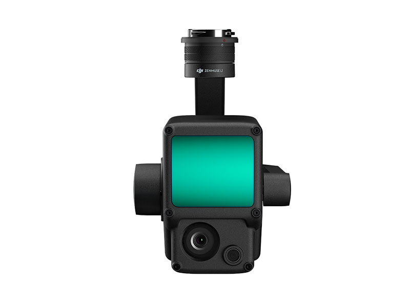
What is the field of view of the L1's Lidar?
In Non-repetitive Scanning mode, the FOV is 70.4°x77.2°.
In Repetitive Scanning mode, the FOV is 70.4°x4.5°.
What is the maximum measuring range of the L1?
The maximum measuring range of the L1 is 190m@10%, 100klx ; 450m@80%, 0klx.
The recommended typical working height is 50m-120m.
What is the scanning frequency of the L1?
The L1 provides three scanning frequencies: one/two returns: 80K/s, 160K/s, and 240K/s; three returns: 80K/s, 240K/s.
How many
scanning modes does the L1 Have?
The L1 has two scanning modes: Non-repetitive Scanning mode and Repetitive Scanning mode
How many returns does the L1 Support?
The L1 supports 3 types of returns:
One return;
Two returns;
Three returns.
What does the L1's Point Cloud LiveView do?
The L1 collects point cloud models based on RTK and displays the collected models on Pilot in real time.
The following features are supported:
· Rotating, dragging, zooming, quick switching of perspectives, and centering;
· Multiple coloring modes including RGB, reflectivity, elevation and distance;
How does the L1 perform high-accuracy post-processed modelling?
For high-accuracy post-processed modeling, you can import the data from the SD card into DJI Terra with one click. This will generate a colorized point cloud model with high-accuracy PPK-IMU position and orientation calculation supported.
Which model reconstruction formats does the L1 support?
The L1 currently supports Mapping, Linear Flight Mission, Oblique and Waypoint.
What is the IMU Accuracy of the L1?
In typical operating scenarios, the IMU accuracy of the L1 is 0.025°(roll/pitch)/0.15°(yaw)
What is the L1's Auxiliary vision sensor used for?
The vision sensor provides altitude data. This means that if the GNSS signal temporarily fails, the aircraft's accuracy will not be affected for up to 60 seconds. Support coming soon.
What is the L1's RGB camera used for?
The RGB camera of the L1 provides basic functions for taking photos and recording videos and provides real-time color information for the point cloud data during the scanning process. This allows the L1 to output true color point clouds and reality models.
Note that Lidar scanning and video recording cannot work simultaneously.
What is the surveying and mapping accuracy of the L1?
The vertical accuracy of the L1 can reach 5 cm and the horizontal accuracy can reach 10 cm. The accuracy was measured under the following conditions in a DJI laboratory environment: after a 5-minute warm up, using Mapping Mission with Calibration Flight enabled in DJI Pilot, and with the RTK in FIX status. The relative altitude was set to 50 m, flight speed to 10 m/s, gimbal pitch to -90°, and each straight segment of the flight route was less than 1000 m. DJI Terra was used for post-processing.
Can the L1 work at night?
The Lidar module of the L1 has active detection capability which can scan terrain to collect point clouds during night-time or other low light conditions.
Which scanning mode does the L1's lidar module adopt?
The Lidar module of the L1 adopts an Advanced Frame Scanning mode. This ensures that all point clouds collected are valid point cloud data.
How efficient is the surveying and mapping operation of the L1?
At a flight height of 100 m and a velocity of 13 m/s, a single flight with the M300 RTK and the L1 can collect data covering an area of 2 km2.
What are the application scenarios of the Zenmuse L1?
The L1 can be widely used in multiple scenarios including:
· Topographic surveying and mapping
· Power transmission line corridor modeling
· Emergency response surveying and mapping
· Detailed modeling
· Agriculture & forestry investigation
On which gimbal of the M300 RTK can the L1 be mounted?
The L1 can be mounted on the right downward gimbal port (when facing the drone) of the M300 RTK. Currently, only suppot single gimbal mode.

 SlantRange 4P+
 NextCore RN50 Drone LiDAR
 Cendence-S Remote Controller For M200 V2 Series
 DJI FPV Lumicopter
 DJI Mavic 3 Multispectral With 2 Year Care Basic
  DJI Mavic 3 Multispectral With 1 Year Care Basic
  DJI Mavic 3 Thermal with 2 Year Care Basic
 DJI Mavic 3 ThermalWith 1 Year Care Basic
 AGRAS T40
 DJI Mavic 3 Enterprise With 1 Year Care Basic
 DJI Mavic 3 Enterprise with 2 Year Care Basic
 Matrice M30
 Matrice M30T
 Matrice M30 with Enterprise Care Plus
 Matrice M30T with Enterprise Care Plus
 Deepthink S2 Pro Night Vision Payload for Matrice 300 Series
 Matrice 350 RTK
 DJI RC Plus for Matrice Series
 Zenmuse H20N
 DJI FlyCart 30
 DJI RC Plus for DJI FlyCart 30
 Mavic 2 Enterprise Advanced
 Ex-Rental DJI Mavic 2 Enterprise Advanced
 Ex-Rental DJI Mavic 2 Enterprise Dual
 DJI AGRAS T10 (Excludes Batteries)
 DJI Dock 2
 DJI Matrice 3D
 DJI Matrice 3TD
 DJI Dock
  DJI Power 500
 DJI Power 1000
 Matrice 600 Pro
 Matrice 210 RTK V2 + D-RTK 2 Combo (Including Battery)
 Matrice 210 V2 Combo (Including Battery)
 Matrice 210 (DJI Refurbished)
 DJI D-RTK 2 Base Station Tripod
 Phantom 4 RTK Combo
 Ex-Rental DJI P4RTK with Base Station and Tripod (3 Batteries)
 Phantom 4 Multispectral Combo
 Phantom 4 Multispectral + D-RTK 2 High Precision GNSS Mobile Station Combo
 Chasing M2 Pro with Chasing Reel
 Chasing M2 With 200m Tether
 Enterprise Shield Plus ( Phantom 4 RTK ) AU
 Enterprise Shield Plus ( P4 Multispectral)
 Enterprise Shield Plus (Mavic 2 Enterprise (Dual ))AU
 Enterprise Shield Plus (Mavic 2 Enterprise (Zoom)) AU
 DJI Care Enterprise Basic Auto-Activation (P1)
 Enterprise Shield Basic Auto-Activation for Mavic 2 Enterprise Advanced
 Enterprise Shield Basic for Mavic 2 Enterprise Advanced RTK Module
 DJI Maintenance Program Basic Service (Phantom 4 Series)
 DJI Maintenance Program Standard Service (Mavic 2 Series)
 DJI Maintenance Program Standard Service (Phantom 4 Series)
 DJI Maintenance Program Standard Service(M300RTK)
 Soarability Speedip Water Sampling System
 Sniffer4D Mini2 Base Unit
 Sniffer4D TDLAS Methane Sensing Module
 Sniffer4D Ground Vehicle Integration Kit
 Micasense RedEdge-P
 Micasense RedEdge-P Multispectral Kit + DJI Skyport for M200 or 210
 Micasense RedEdge-P Multispectral Kit + DJI Skyport for M300
 Micasense Altum M300 Quick mount kit
 Tello
Tello Tello Boost Combo
 Tello EDU
 RoboMaster S1
 GameSir T1d Controller
 SunnyLife Carrying Case for Tello
 Tello Flight Battery
 SunnyLife Battery Charging Hub for Tello
 Sunnylife Carrying Bag For DJI RoboMaster S1
  RoboMaster S1 PlayMore Kit V2
  RoboMaster S1 Intelligent Battery V2
  RoboMaster S1 Gamepad V2
 SanDisk Extreme Pro 128GB 200MB/s MicroSD Card
 SanDisk Extreme Pro 256GB 200MB/s MicroSD Card
 SanDisk Extreme Pro 512GB 200MB/s MicroSD Card
 PGYTECH CreateMate High-Speed Card Reader Case
 DJI Mini 4 Pro Fly More Combo
 DJI Mini 4 Pro Fly More Combo Plus
 DJI Mini 4 Pro
 DJI Mini 4 Pro w. DJI RC 2
 DJI Mini 3 Pro with DJI RC
  DJI RC
 DJI Mini 3 w. DJI RC
 DJI Mini 3
 DJI Mini 3 Fly More Combo Plus
 DJI Mini 3 Fly More Combo Plus w. DJI RC
 DJI Mini 2 SE
 DJI Mini 2 SE Fly More Combo
 DJI Mini SE
  DJI Mini 2
 DJI Mini 2 Fly More Combo
  Ex-Demo Mavic Mini Fly More Combo
 Mavic Mini
 Mavic Mini Fly More Combo
  DJI Air 3 Fly More Combo w. DJI RC 2
 DJI Air 3
 DJI Air 3 Fly More Combo
 DJI Air 2S
 DJI Air 2S Fly More Combo
 Mavic Air 2 Fly More Combo
 Mavic Air 2
 Ex-Demo Mavic Air Combo (Onyx Black)
 Ex-Demo Mavic Air Combo (Arctic White)
 Ex-Demo Mavic Air Combo (Flame Red)
 Ex-Demo Mavic Air (Arctic White)
 DJI Mavic 3 Pro w. DJI RC
 DJI Mavic 3 Pro Fly More Combo w. DJI RC
 DJI Mavic 3 Pro Fly More Combo w. DJI RC Pro
 DJI Mavic 3 Pro Cine Premium Combo
 DJI Mavic 3 Classic w. DJI RC
  DJI Mavic 3 Classic w. DJI RC-N1
 DJI Mavic 3 Classic (Drone Only)
 Ex-Demo Mavic 3 Classic w. DJI RC
 DJI Mavic 3
  DJI Mavic 3 Fly More Combo
  DJI Mavic 3 Cine Combo w. DJI RC-N1
 DJI RC Pro Controller
 Ex-Demo Mavic 2 Pro Fly More Combo
 Mavic 2 Zoom
 Mavic 2 Pro
 Ex-Demo Mavic Pro
 Mavic Pro Fly More Combo
 Demo Mavic Pro Platinum Combo
 DJI Avata 2 Fly More Combo
 DJI Avata 2 Fly More Combo (Three Batteries)
 DJI Avata Explorer Combo
 DJI Avata
  DJI Avata Pro-View Combo w. DJI RC Motion 2
 DJI Avata Fly Smart Combo
 DJI Goggles 3
 DJI Goggles Integra Motion Combo
 DJI Goggles Integra
 DJI Goggles 2 Motion Combo
 DJI FPV Combo
  DJI O3 Air Unit
 Osmo Pocket 3 Standard Combo
 Osmo Pocket 3 Creator Combo
 Osmo Action 4 Standard Combo
 Osmo Action 4 Adventure Combo
 DJI Mic 2 Dual Microphone Combo
 DJI Mic 2 Single Microphone Kit
 Osmo Mobile 6 (Slate Grey)
 Osmo Mobile 6 (Platinum Grey)
 Osmo Mobile SE
 Osmo Action 3 Standard Combo
 Osmo Action 3 Adventure Combo
  DJI Mic Single Microphone Kit
 DJI Mic Dual Microphone Combo
 DJI Pocket 2
 DJI Pocket 2 Creator Combo
 DJI Pocket 2 Exclusive Combo | Sunset White
 DJI Action 2 Dual-Screen Combo (128GB)
 DJI Action 2 Power Combo (128GB)
 DJI Action 2 Dual Screen Combo
 DJI Action 2 Power Combo
 DJI Osmo Action
  Osmo Pocket
 DJI RS 4
 DJI RS 4 Combo
 DJI RS 4 Pro
 DJI RS 4 Pro Combo
 DJI RS 3 Pro Combo
 DJI RS 3 Mini
 DJI RS 3
 DJI RS 3 Combo
 DJI RSC 2 Pro Combo
 DJI RS 2
 DJI RS 2 Pro Combo
 DJI RSC 2
 Ronin-S
 Ronin-SC
 Ronin 2 Professional Combo
  Ronin 4D-6K
 Ronin 4D-8K
 Zenmuse X9-8K Gimbal Camera
 DJI Ronin 4D Flex
 DJI Inspire 3
 DJI Focus Pro Creator Combo
 DJI Focus Pro All-In-One Combo
 DJI Transmission (High-Bright Monitor Combo)
 DJI Transmission (Standard Combo)
 DJI Video Transmitter
 DJI Video Receiver
 DJI DL 50mm F2.8 LS ASPH Lens
 DJI DL PZ 17-28mm T3.0 ASPH Lens
 DJI DL 18mm F2.8 ASPH Lens
 DJI DL 24mm F2.8 LS ASPH Lens
 Inspire 2
  Inspire 2 Includes Apple ProPres & CinemaDNG Licenses
 Ex-Demo Inspire 2
 H6D-100c
  Lens Shade XCD 21mm
 Lens Shade XCD 65mm
 X1D II 50C
 D1 Labs Landing Pad Pro (50CM)
 UGREEN 100W USB-C Charging Station
 Caution Drone Safety Sign
 D1 Labs Air Duster Pro
 DJI Care Refresh 1-Year Plan (DJI Mini 3 Pro)
 DJI Care Refresh 2-Year Plan (DJI Mini 3 Pro)
 DJI Mini 3 Series Intelligent Flight Battery
 DJI Mini 4 Pro/Mini 3 Series Intelligent Flight Battery Plus
 DJI Care Refresh 1-Year Plan (DJI Mavic 3)
 DJI Care Refresh 2-Year Plan (DJI Mavic 3)
 DJI Care Refresh 1-Year Plan (DJI Mavic 3 Cine)
 DJI Care Refresh 2-Year Plan (DJI Mavic 3 Cine)
 Mavic 2 Intelligent Flight Battery
 Mavic 2 Low-Noise Propellers (Pair) [No Retail Packaging}
 Mavic 2 Protector Case
 DJI Smart Controller
  Gimbal Camera Cover for DJI Phantom 4 Pro
 Phantom 4 Series Intelligent Flight Battery
 Phantom 4 Car Charger
 Phantom 4 Battery Charging Hub
 SunnyLife Propellers for Mavic Mini
 Mavic Mini Intelligent Flight Battery
 DJI Mini 2 / SE Two-Way Charging Hub
 Mavic Mini Propellers (set)
 PGYTECH CPL Filter for Osmo Pocket Series (Professional)
 DJI Pocket 2 Phone Clip
 Osmo Pocket 3.5mm Adapter
 Osmo Pocket Extension Rod
 Osmo Action Battery
 Osmo Action Charging Kit
 CYNOVA Osmo Action Dual 3.5mm/USB-C Adapter
 DJI OM Magnetic Phone Clamp 3
 DJI Care Refresh 2-Year Plan (Osmo Mobile 6)
 DJI Care Refresh 1-Year Plan (Osmo Mobile 6)
 SunnyLife Carrying Case for Osmo Mobile SE / OM4 Series
 Mavic Air Intelligent Flight Battery
  Mavic Air Remote Controller(Open Box)
 Mavic Air Carrying Case
 Mavic Air Battery Charging Hub
 Lens Filter for Mavic Pro (G-HD-ND8)
 Mavic Pro Intelligent Flight Battery
 Gannet Sport for DJI Mavic Series
 Ex-Demo Mavic Pro Remote Controller
 SunnyLife Propellers for DJI Spark
 Spark - Propeller Guards
 Spark - Quick-Release Folding Propellers
 SunnyLife Spark Intelligent Battery Car Charger With USB Port
 Ex-Demo Zenmuse X5S
 DJI Care Refresh (Inspire 2)
 Zenmuse X5S
 Zenmuse X7 (Lens Excluded)
 EM-D1 Drone Skin for DJI Mini 3 Pro
 EM-D1 Drone Skin for DJI Mavic 3 Series
 D1 Labs EM-D1 Desk Pad (Ultraviolet)
 D1 Labs EM-D1 Desk Pad (Stellar)
 PolarPro Mavic 2 Pro Cinema Series 2-5 Stop VND Filter
 PolarPro Vivid Collection Filters for Mavic Air 2 (3 Pack)
 PolarPro 2 to 5 Stop VND Filter for Mavic Air 2
 PolarPro CrystalSky Mount | Mavic/Spark
  UGREEN HiTune T3 Active Noise Cancelling Earbuds (Black)
 UGREEN HiTune T3 Active Noise Cancelling Earbuds (White)
 UGREEN 35W Nexode GaN II Charger
 UGREEN 65W Nexode GaN II Charger
 Gannet Sport for Phantom Series
 Gannet Electronic Payload Release System for Mavic 2
 Gannet Elite for DJI Mavic 3 Series
 DJI Matrice 300 6 Battery Case
 GPC Hard Case for DJI M30 Series
 GPC Safety Case for DJI Air 2S
 GPC Safety Case for DJI FPV
 D1 VIP Drone Set-Up Service
 D1 Beginners Flight Training (Brunswick, VIC)
 Remote Pilots License (RePL)
  DJI Maintenance Course Training
 D1 Labs Landing Pad Pro (65CM)
 D1 Labs Landing Pad Pro (100CM)
 D1 Labs Weighted Drone Landing Pad (67CM)
 Ulanzi RGB Handheld Tube Light | VL119
 Ulanzi Vijim RGB Light | VL120
 Ulanzi Mini RGB LED Light | VL49
  Ulanzi Waterproof Cube Light
 PGYTECH OneMo Lite Backpack 22L
 PGYTECH OneMo FPV Backpack
 PGYTECH OneGo Backpack 18L | Obsidian Black
 PGYTECH OneMo 2 Backpack 25L | Space Black
 DJI RC-N1/N2 Control Sticks
 SunnyLife Bicycle Mount for DJI RC-N1/N2
 Mavic Tablet Holder v2
 LifThor Baldur 2 Tablet Holder for DJI RC-N1/N2
 SunnyLife Rocker Speed Controller for DJI RC
 DJI Drone Controller Lanyard
 SunnyLife Control Sticks for DJI RC Series
 LifThor Tripod Bracket for DJI RC Pro
 D1 Labs Screen Protector for DJI RC Pro
 Bicycle Bracket & Clamp for DJI RC Pro
 SunnyLife Sun Hood for DJI RC Pro
 Anti-Collision Drone Strobe Light
 High Visibility UAV Pilot Safety Vest - 2XL
 PGYTECH Mantispod
 PGYTECH Mantispod Pro
 Freewell All Day Filters for Osmo Pocket 3 (8 Pack)
 Freewell Bright Day Filters for Osmo Pocket 3 (4 Pack)
 Freewell CPL Filter for Osmo Pocket 3
 Freewell Mega Filter Pack for Osmo Pocket 3 (14 Pack)
 Freewell Sherpa Series 1.33x Gold Anamorphic Lens
 Freewell Sherpa Series 1.55x Blue Anamorphic Lens
 Freewell Sherpa Series 1.55x Gold Anamorphic Lens
 Freewell Sherpa Series 1.7x Telephoto Lens
 Freewell Galaxy Series Snow Mist 1/4 Filter
 Freewell Versatile Bluetooth Smartphone Selfie Grip
 Freewell Galaxy Series Case for Samsung Galaxy S23 Ultra
 DJI RC Motion 3
 DJI FPV Controller 3
 DJI RC 2
 PGYTECH CFexpress CreateMate Card Reader Case (CFE-A/SD)
 PGYTECH Camera Shoulder Strap
 PGYTECH Camera Wrist Strap
 D1 Lens Cloth
 D1 Labs Dual Hook Controller Lanyard
 D1 Labs Screen Protector for DJI RC Series
 DJI Care Refresh 1-Year Plan (DJI Mavic 3 Pro)
 DJI Care Refresh 1-Year Plan (DJI Mini 4 Pro)
 DJI Care Refresh 1-Year Plan (DJI Mini 2 SE)
 DJI Care Refresh 1-Year Plan (Osmo Mobile SE)
 DJI Care Refresh 1-Year Plan (DJI RS 3 Mini)
 DJI Care Refresh 2-Year Plan (DJI Mini 2 SE)
 DJI Care Refresh 2-Year Plan (Osmo Mobile SE)
 DJI Care Refresh 2-Year Plan (DJI RS 3 Mini)
 DJI Care Refresh 2-Year Plan (DJI Mavic 3 Pro)
 Enterprise Shield For Mavic 2 Zoom
 Enterprise Shield For Phantom 4 RTK
 Enterprise Shield Mavic 2 Dual
 Enterprise Shield Basic Renew (Mavic 2 Enterprise Dual)
 Enterprise Shield Basic Renew (M200 V2)
 Enterprise Shield Basic Renew (M210 RTK V2)
 Enterprise Shield Basic Renew (M210 V2)
 D1 Labs Safety Case Foam Insert for DJI Mini 4 Pro
 D1 Labs Safety Case for DJI Mini 3 Pro
 D1 Labs Safety Case for DJI Mini 4 Pro
 D1 Labs Safety Case for DJI Air 3
 Spectre | Drone Brick Model
  D1 Labs Tidal Wave Desk Pad
 D1 Labs Screen & Lens Protector for Osmo Action 4
 D1 Labs Screen & Lens Protector for Osmo Pocket 3
 Yule Whispers Drone Skin for DJI Mini 4 Pro
 Auspicious Sky Drone Skin for DJI Mini 4 Pro
 Auspicious Sky Drone Skin for DJI Air 3
 Auspicious Sky Drone Skin for DJI Mavic 3 Series
 Auspicious Sky Drone Skin for DJI Mini 3 Pro
 Yule Whispers Drone Skin for DJI Mini 3 Pro
 Cerulean Flight Drone Skin for DJI Mini 3 Pro
 Ulanzi Anamorphic Lens for DJI Mavic 3
 DJI RC-N1/N2 Remote Controller Monitor Hood
 PGYTECH Protector for DJI Smart Controller
 Ex-Demo DJI Mavic 3
 Ex-Demo DJI Avata Fly Smart Combo
 Ex-Demo DJI Avata Fly More Kit
 Ex-Demo DJI RS 3
 Ex-Demo DJI RS 3 Combo
 Ex-Demo DJI RS2
 Ex-Demo DJI OM 5 (Athens Grey)
 Ex-Demo Tello Battery
 Ex-Demo DJI Mini 2 / SE Intelligent Flight Battery
 Ex-Demo DJI Mini 3 Series Intelligent Flight Battery
 Ex-Demo DJI Mini 3 Series Intelligent Flight Battery Plus